|
|
|
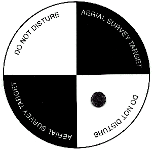
What is an Aerial Target? Below is an Aerial Control Target. This one is the size that we use in the field for Helicopter imagery. The accuracy in the work flown from our helicopter is in the area of 1/100th of a foot. In simple terms the height of a paint stripe. That is incredible results! The best part is that utilizing this type of photography for mapping purposes has saved the lives of many surveyors. They no longer have to be in the roads. For example a project in Richmond, VA was flown with a helicopter in 10 minutes. They closed the interstate in both directions for the helicopter to fly over. Then the interstate was re-opened. If this work was done by traditional surveying the interstate would have had one lane at a time closed for about 3 to 5 months.You will find targets are normally several feet long and as much as 20 feet for extremely high altitude coverage. SO, if you see these in the road or on your property, it is to allow an accurate map to be made that includes the property you are on. PLEASE leave them there because the map made may end up in your car some day.
A couple common targets commonly used target found on the lower left and sizes vary from 6 inches to 20 feet. You may find while hiking in the woods just as often as walking down the street.
|